Worcestershire Tourist Guide - Articles
Worcestershire Walks and Countryside
Worcestershire has more than 3000 miles of footpaths and bridleways through spectacular countryside, including the Malvern Hills which has a 100 miles for walking, cycling and horse riding. The county of Worcestershire has one of the most varied and panoramic landscapes to be found anywhere in England.... countryside just waiting to be explored.
For all your outdoor requirements visit the Army & Outdoor Store
A number of walking guides are available from county Tourist Information Centres
WALKING IN WORCESTERSHIRE
All the information you need to get walking in the beautiful Worcestershire countryside.
More than 110 free Walk descriptions to download free of charge.
www.walkinginworcestershire.co.uk
Short Distance Trails - Worcestershire
WALKS IN NORTH WORCESTERSHIRE
Stoke Parish Walks featuring the communities of Stoke Heath, Stoke Pound, Stoke Prior and Stoke Works.
There are a number of walks in the parish that enable visitors to experience all aspects of life in the parish of Stoke, with many pubs and inns along the way for a welcome rest.
Stoke Prior and Upton Warren Walk This walk starts in the industrial village of Stoke Works built by John Corbett, the Salt King. The path circles the Upton Warren Nature Reserve and Sailing Centre. It is well worth bringing binoculars. Boots are recommended except in the driest weather.
Avoncroft Museum and St Michael's Church
This walk provides several unusual angles and it is worth bringing a camera. In summer shoes are adequate but boots are better in winter. There are now no stiles on the main path and some stiles will be removed from the shorter alternative.
Stoke Flight and Woodgate
Charming canal side walk followed by mainly open countryside. The towpath runs alongside the Stoke Flight and then the bottom locks of the long Tardebigge Flight. In total the canal climbs over 250 feet from the Severn Valley to the Birmingham Plateau. Boots are desirable. It is hoped to replace more stiles with gates.
Dodderhill Common and Hanbury Hall
A more strenuous walk particularly up to Hanbury Church. Fine views followed by mature parkland. Boots advisable in wet weather. The route has been further revised to use the waymarked path around Harris Brushworks.
Pipers Hill and Two Trees Hill
A more energetic walk with some surprising magnificent views. Most people will find it easier to leave the car at either Bromsgrove Station or the Jinney Ring Craft Centre and catch the 940 bus to the other end. The canal, Copyholt Lane and Woodgate Road provide connecting links for shorter circular walks. Boots are advisable except in driest weather. Please keep to the rights of way within the Fosterís Green Meadow National Nature Reserve. The walk is best done anti-clockwise to ease the uphill stretches.
The Lickey Incline and Tardebigge Flight
The walk starts at Stoke Works, criss-crosses the railway up hill with an easy stroll back down the canal towpath. In dry weather only sensible footwear is needed. The link-paths can become muddy and overgrown making boots and trousers sensible at other times. Bring a telephoto lens with your camera.
THE ROYAL HUNTERS' WALKS
Three well-maintained, way-marked walks which start at Sanders Park on the edge of Bromsgrove and head north-west to explore the delightful woods, meadows and paddocks between Bromsgrove and Chaddesley Corbett.
The Royal Hunters Walks - Distance 5, 8 & 12 miles / 8, 13 & 19 km Waymarked walks.
Simply follow the 'Royal Hunters' symbol and direction arrows and you won't get lost.
Travel back in time from the very heart of bustling Bromsgrove to the hunting forests of the Middle Ages. The countryside around here gives a rich and vibrant picture of Royal Hunting Forests, the rise of Chartist settlements, priories, visiting kings and much more. Through three waymarked circular walks you can explore the fascinating heritage that this part of Worcestershire has to offer.
The HEDGELAYERS' is 5 miles long, the CHARTISTS' WALK is 8 miles and the FORESTERS' WALK is 12 miles, but the three share a common route from Sanders Park as far as Dodford and back again.
Between Sanders Park and Park Gate Inn the outward and return routes are identical, meaning walkers have to retrace their steps.
This area was once part of the Royal Forest of Feckenham, hence the name Royal Hunters' Walks. While the names of the Hedgelayers' Walk and Foresters' Walk are self-explanatory, the Chartists' Walk takes its name from a radical, democratic political movement which flourished from 1838 to 1850.
The Chartists were named for their People's Charter, a six-point programme that included universal male suffrage and abolition of payments for members of parliament. Dodford was purpose-built around 1840 as a Chartist settlement, providing formerly landless town dwellers with the chance to try and make a living as market gardeners.
The HEDGELAYERS' WALK is the shortest of the three at 5 miles. Explore in depth the trees, shrubs and hedgerow plants that were so vital for everyday life in the middle ages. They provided local people with food, tools, building materials, cooking fuel, shelter for stock and even diviners rods. Hedges were also often used as parish boundaries. The route through rolling farmland goes to the fascinating village of Dodford, via ancient lanes and tracks.
The CHARTISTS' WALK takes you through predominantly pastoral rolling hills, dotted with farms, houses and ancient woodlands along its 8 miles route. Quiet lanes, byways, medieval tracks and footpaths are used, as the story unfolds of the 19th century Chartists' political movement at the planned settlement of Dodford, quite unlike any other. Enjoy typical trackside flowers like vetches, Cow-parsley and Buttercups as you tread in the footsteps of the Chartists.
At 12 miles, the FORESTERS' WALK is the longest and explores the impressive remnants of the Royal Hunting Forest of Feckenham. Traditional wildflower meadows and rolling farmland create the backdrop for this walk. The glorious ancient woodlands along this route are provocative reminders of times gone by. Chaddesley Wood Nature Reserve is managed as a valuable remnant of the ancient woodland, and is home to important species of plants, animals, birds and insects. Oak trees dominate the woodland with Rowan, Birch, Hazel and Hawthorn mixed in. Carpets of Bluebells in the woods are a good sign of undisturbed ground.
This countryside is the birthplace of the poet A. E. Houseman, and it's not hard to see what inspired him. It paints a rich and vibrant picture of ancient broadleaved woodlands, coppices, orchards, hedgerow fruits, farmland, delightful stream valleys lush with ferns, and the greatest concentration within Worcestershire of nationally scarce wildflower meadows and pastures that are a delight to behold.
CROOME PARK - NATIONAL TRUST
Based in Worcestershire, Croome Park is a great place to walk your dog.
There are dog friendly maps, water bowls, waste bags, tether points and nine waste bins around the park so you can enjoy your walkies.
Your dog can go anywhere on a lead around the park and lakeside and you can pick up a map at reception to see the areas where they can go off the lead too.
We have two large marquees outside the Cafť at the Visitor Reception Centre so you can enjoy a cup of tea, a cake or a hot meal with your dog.
Donít leave your dog in your car Ė let them enjoy Croome with you.
Walking Your Dog at Croome Park
CASTLEMORTON COMMON
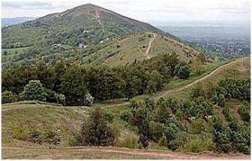
Castlemorton Common is at the foot of the Malvern Hills. It surrounds the villages of Castlemorton, Welland, and Birtsmorton.
The Castlemorton Commons are a beautiful and peaceful place to visit. Many people choose to visit just to walk or exercise their dog but many people also horse ride on the Common or have a picnic.
Situated at the foot of the Malvern Hills near Castlemorton Common you will find the Plume Of Feathers a welcome stop for a drink or a meal.
MALVERN WALKING FESTIVAL
The Malvern Walking Festival will take place from Saturday 26th May to Sunday 3rd June 2018.
A walking festival over 9 days led by enthusiastic and knowledgeable guides in and around the Malvern Hills and even further.
Truly an Area of Outstanding Natural Beauty. Come and stay in the area and join a walk or two.
Detailed leaflets available from the Tourist Information Centre.
Visit Malvern Walking Festival Website
GUIDED WALKS AROUND MALVERN VICTORIAN TOWN
Malvern Town Walk - Guided walk around Victorian Malvern narrated by Malvern Civic Society guides. Saturday at 10.30am and Sunday at 2.30pm from April to September. Duration approx. 1.5 hrs. Start point and tickets: Malvern Tourist Information Centre Tourist Information Centre
GUIDED TOWN WALKS - EVESHAM
Add extra interest to your visit to the historic town of Evesham with a guided tour. A friendly qualified Tour Guide will tell you the story of Evesham's past. Tours leave the Almonry Heritage Centre in Evesham every Tuesday from May to August at 2.30pm Lasting approximately one hour and costing £1 per person, this tour is packed full of historical and enlightening facts. Pre booking is advisable. Call 01386 446944
10 WALKS AROUND MARTLEY
The Parish of Martley has a network of footpaths, made up of 296 separate links, total length around 42 miles (60km footways, 7km bridleways).
The Path or nones has Free print outs of walks around Martley for you to enjoy.
THE WORCESTERSHIRE WAY
This 31 mile walking trail from the riverside town of Bewdley to Great Malvern, beneath the Malvern Hills, will lead you through picturesque villages of Abberley, Martley and Knightwick and the valleys of the River Teme and Severn.
SEVERN WAY
A 221 mile waymarked walking trail from the source of River Severn in mid-Wales to the Bristol Channel. Along the way, you are sure to find beautiful scenery, wonderful accessible wildlife, fascinating industrial history, comfortable riverside walking, historic villages, towns and cities, and welcoming places to eat, drink and stay.
WYCHAVON WAY
A 42 mile waymarked walking trail stretching from Holt Fleet, a bridging point on thr River Severn north of Worcester, to Winchcombe in the Cotswolds.
ILLEY WAY
Follow approximately 5 miles of waymarked walking trail between the Waseley Hills and Woodgate Valley Country Parks. Taking in rich meadows and quiet woodland.
ELGAR ROUTE - A DRIVE AROUND WORCESTERSHIRE
A 40 mile circular driving route passing through Worcester City and Great Malvern. The route has been designed so you may join it at any convenient point, with over 40 places of interest assosciated with Sir Edward Elgar's life and music along the way.
A leaflet giving details of the route is available at most Tourist Information Centres
For all your outdoor requirements visit the Army & Outdoor Store
A number of walking guides are available from county Tourist Information Centres
WALKING IN WORCESTERSHIRE
All the information you need to get walking in the beautiful Worcestershire countryside.
More than 110 free Walk descriptions to download free of charge.
www.walkinginworcestershire.co.uk
Short Distance Trails - Worcestershire
WALKS IN NORTH WORCESTERSHIRE
Stoke Parish Walks featuring the communities of Stoke Heath, Stoke Pound, Stoke Prior and Stoke Works.
There are a number of walks in the parish that enable visitors to experience all aspects of life in the parish of Stoke, with many pubs and inns along the way for a welcome rest.
Stoke Prior and Upton Warren Walk This walk starts in the industrial village of Stoke Works built by John Corbett, the Salt King. The path circles the Upton Warren Nature Reserve and Sailing Centre. It is well worth bringing binoculars. Boots are recommended except in the driest weather.
Avoncroft Museum and St Michael's Church
This walk provides several unusual angles and it is worth bringing a camera. In summer shoes are adequate but boots are better in winter. There are now no stiles on the main path and some stiles will be removed from the shorter alternative.
Stoke Flight and Woodgate
Charming canal side walk followed by mainly open countryside. The towpath runs alongside the Stoke Flight and then the bottom locks of the long Tardebigge Flight. In total the canal climbs over 250 feet from the Severn Valley to the Birmingham Plateau. Boots are desirable. It is hoped to replace more stiles with gates.
Dodderhill Common and Hanbury Hall
A more strenuous walk particularly up to Hanbury Church. Fine views followed by mature parkland. Boots advisable in wet weather. The route has been further revised to use the waymarked path around Harris Brushworks.
Pipers Hill and Two Trees Hill
A more energetic walk with some surprising magnificent views. Most people will find it easier to leave the car at either Bromsgrove Station or the Jinney Ring Craft Centre and catch the 940 bus to the other end. The canal, Copyholt Lane and Woodgate Road provide connecting links for shorter circular walks. Boots are advisable except in driest weather. Please keep to the rights of way within the Fosterís Green Meadow National Nature Reserve. The walk is best done anti-clockwise to ease the uphill stretches.
The Lickey Incline and Tardebigge Flight
The walk starts at Stoke Works, criss-crosses the railway up hill with an easy stroll back down the canal towpath. In dry weather only sensible footwear is needed. The link-paths can become muddy and overgrown making boots and trousers sensible at other times. Bring a telephoto lens with your camera.
THE ROYAL HUNTERS' WALKS
Three well-maintained, way-marked walks which start at Sanders Park on the edge of Bromsgrove and head north-west to explore the delightful woods, meadows and paddocks between Bromsgrove and Chaddesley Corbett.
The Royal Hunters Walks - Distance 5, 8 & 12 miles / 8, 13 & 19 km Waymarked walks.
Simply follow the 'Royal Hunters' symbol and direction arrows and you won't get lost.
Travel back in time from the very heart of bustling Bromsgrove to the hunting forests of the Middle Ages. The countryside around here gives a rich and vibrant picture of Royal Hunting Forests, the rise of Chartist settlements, priories, visiting kings and much more. Through three waymarked circular walks you can explore the fascinating heritage that this part of Worcestershire has to offer.
The HEDGELAYERS' is 5 miles long, the CHARTISTS' WALK is 8 miles and the FORESTERS' WALK is 12 miles, but the three share a common route from Sanders Park as far as Dodford and back again.
Between Sanders Park and Park Gate Inn the outward and return routes are identical, meaning walkers have to retrace their steps.
This area was once part of the Royal Forest of Feckenham, hence the name Royal Hunters' Walks. While the names of the Hedgelayers' Walk and Foresters' Walk are self-explanatory, the Chartists' Walk takes its name from a radical, democratic political movement which flourished from 1838 to 1850.
The Chartists were named for their People's Charter, a six-point programme that included universal male suffrage and abolition of payments for members of parliament. Dodford was purpose-built around 1840 as a Chartist settlement, providing formerly landless town dwellers with the chance to try and make a living as market gardeners.
The HEDGELAYERS' WALK is the shortest of the three at 5 miles. Explore in depth the trees, shrubs and hedgerow plants that were so vital for everyday life in the middle ages. They provided local people with food, tools, building materials, cooking fuel, shelter for stock and even diviners rods. Hedges were also often used as parish boundaries. The route through rolling farmland goes to the fascinating village of Dodford, via ancient lanes and tracks.
The CHARTISTS' WALK takes you through predominantly pastoral rolling hills, dotted with farms, houses and ancient woodlands along its 8 miles route. Quiet lanes, byways, medieval tracks and footpaths are used, as the story unfolds of the 19th century Chartists' political movement at the planned settlement of Dodford, quite unlike any other. Enjoy typical trackside flowers like vetches, Cow-parsley and Buttercups as you tread in the footsteps of the Chartists.
At 12 miles, the FORESTERS' WALK is the longest and explores the impressive remnants of the Royal Hunting Forest of Feckenham. Traditional wildflower meadows and rolling farmland create the backdrop for this walk. The glorious ancient woodlands along this route are provocative reminders of times gone by. Chaddesley Wood Nature Reserve is managed as a valuable remnant of the ancient woodland, and is home to important species of plants, animals, birds and insects. Oak trees dominate the woodland with Rowan, Birch, Hazel and Hawthorn mixed in. Carpets of Bluebells in the woods are a good sign of undisturbed ground.
This countryside is the birthplace of the poet A. E. Houseman, and it's not hard to see what inspired him. It paints a rich and vibrant picture of ancient broadleaved woodlands, coppices, orchards, hedgerow fruits, farmland, delightful stream valleys lush with ferns, and the greatest concentration within Worcestershire of nationally scarce wildflower meadows and pastures that are a delight to behold.
CROOME PARK - NATIONAL TRUST
Based in Worcestershire, Croome Park is a great place to walk your dog.
There are dog friendly maps, water bowls, waste bags, tether points and nine waste bins around the park so you can enjoy your walkies.
Your dog can go anywhere on a lead around the park and lakeside and you can pick up a map at reception to see the areas where they can go off the lead too.
We have two large marquees outside the Cafť at the Visitor Reception Centre so you can enjoy a cup of tea, a cake or a hot meal with your dog.
Donít leave your dog in your car Ė let them enjoy Croome with you.
Walking Your Dog at Croome Park
CASTLEMORTON COMMON
Castlemorton Common is at the foot of the Malvern Hills. It surrounds the villages of Castlemorton, Welland, and Birtsmorton.
The Castlemorton Commons are a beautiful and peaceful place to visit. Many people choose to visit just to walk or exercise their dog but many people also horse ride on the Common or have a picnic.
Situated at the foot of the Malvern Hills near Castlemorton Common you will find the Plume Of Feathers a welcome stop for a drink or a meal.
MALVERN WALKING FESTIVAL
The Malvern Walking Festival will take place from Saturday 26th May to Sunday 3rd June 2018.
A walking festival over 9 days led by enthusiastic and knowledgeable guides in and around the Malvern Hills and even further.
Truly an Area of Outstanding Natural Beauty. Come and stay in the area and join a walk or two.
Detailed leaflets available from the Tourist Information Centre.
Visit Malvern Walking Festival Website
GUIDED WALKS AROUND MALVERN VICTORIAN TOWN
Malvern Town Walk - Guided walk around Victorian Malvern narrated by Malvern Civic Society guides. Saturday at 10.30am and Sunday at 2.30pm from April to September. Duration approx. 1.5 hrs. Start point and tickets: Malvern Tourist Information Centre Tourist Information Centre
GUIDED TOWN WALKS - EVESHAM
Add extra interest to your visit to the historic town of Evesham with a guided tour. A friendly qualified Tour Guide will tell you the story of Evesham's past. Tours leave the Almonry Heritage Centre in Evesham every Tuesday from May to August at 2.30pm Lasting approximately one hour and costing £1 per person, this tour is packed full of historical and enlightening facts. Pre booking is advisable. Call 01386 446944
10 WALKS AROUND MARTLEY
The Parish of Martley has a network of footpaths, made up of 296 separate links, total length around 42 miles (60km footways, 7km bridleways).
The Path or nones has Free print outs of walks around Martley for you to enjoy.
THE WORCESTERSHIRE WAY
This 31 mile walking trail from the riverside town of Bewdley to Great Malvern, beneath the Malvern Hills, will lead you through picturesque villages of Abberley, Martley and Knightwick and the valleys of the River Teme and Severn.
SEVERN WAY
A 221 mile waymarked walking trail from the source of River Severn in mid-Wales to the Bristol Channel. Along the way, you are sure to find beautiful scenery, wonderful accessible wildlife, fascinating industrial history, comfortable riverside walking, historic villages, towns and cities, and welcoming places to eat, drink and stay.
WYCHAVON WAY
A 42 mile waymarked walking trail stretching from Holt Fleet, a bridging point on thr River Severn north of Worcester, to Winchcombe in the Cotswolds.
ILLEY WAY
Follow approximately 5 miles of waymarked walking trail between the Waseley Hills and Woodgate Valley Country Parks. Taking in rich meadows and quiet woodland.
ELGAR ROUTE - A DRIVE AROUND WORCESTERSHIRE
A 40 mile circular driving route passing through Worcester City and Great Malvern. The route has been designed so you may join it at any convenient point, with over 40 places of interest assosciated with Sir Edward Elgar's life and music along the way.
A leaflet giving details of the route is available at most Tourist Information Centres


